Primary and Secondary Sources
to Support Inquiry Projects about Colonial Connecticut

The Venture Smith Homestead
More about Venture Smith
Link to Venture Smith’s full original Narrative as published in 1798
“The Venture Smith Homestead ” Archaeological Dig Booklet
View of Venture Smith’s Land by John Warner Barber
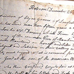
Land Sale, James Green to Venture Smith, June 1793
Slavery
Early Clue about Slavery in Connecticut and New York, 1663
Death of Zeno, a girl of age 6 or 7, Diary of Joshua Hempsted, 1750
Testimony of Elijah Graves
Boyrereau Brinch’s Experience of Slavery in Connecticut, 1763 – 1784
Rev. Levi Hart Calls for an End to Slavery, 1774
An Act Prohibiting the Importation of Slaves, 1774
Prime & Prince of Fairfield, Petition to End Slavery, 1779
Caesar & Lois Peters: Elijah Graves Tells What Happened
Gradual Emancipation Act, 1784
An Act to Prevent (End) Slavery, 1848
MAP: Overview of the Slave Trade Out of Africa, 1500 – 1900. This map is a secondary source. It was created by SlaveVoyages.org. This map shows that the United States was just one place that enslaved people were brought by force to between 1500 and 1900.
Runaway Connecticut, a project of Wesleyan University. This site offers free access to a searchable database of runaway slave ads published in newspapers and scholarly content providing context and insight into slavery-era Connecticut.
Grating the Nutmeg, Episode 149: New London and the Middle Passage. In this podcast episode, Kathy Hermes, Lonnie Braxton, and Tom Schuch discuss the Speedwell, a ship that brought 74 enslaved West Africans to Connecticut in 1761 and Normand Morison, the man who enslaved 21 of them; New London’s Black Heritage Trail and its significance; and the impact of the slave trade on Connecticut and its trading networks.
African Americans in Colonial Connecticut
Cuffee Wells, Revolutionary War soldier, Gilder Lehrman Center
Other Websites
Ancient Burying Ground: Profiles of Africans and Native Americans in Hartford in the Colonial Era
Witness Stones Project, Guilford
Witness Stones Project, West Hartford
Native Americans in Colonial Connecticut
See also Laws about Slavery
Library of Congress
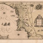
Early Dutch Map of New England, 1630
Map showing Sachemdoms circa 1625
Declaration of War against the Pequot
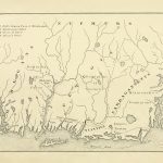
Map of Native American Tribes at the time of the Pequot War, 1637
Hartford Treaty ending the Pequot War, 1638
John Winthrop Jr Scouts a Location for a Settlement, 1645
Notice to the Sachems to Keep Away on Sunday, 1652
John Griffin, Massacoe, and Simsbury’s Early Connection to Shipbuilding, 1663
Uncas and the Border Dispute with New London, 1663
Uncas Signs Colonial Documents in a Special Way, 1662 & 1678
Letter from Rev. Joseph Fish requesting support for a school on the Eastern Pequot Reservation, 1757
Rev. Joseph Fish’s Report on the school on the Eastern Pequot Reservation, 1772 – 1775
Mohegan Petition 1789, Description of Mohegan Way of Life
Other Websites
Mashantucket Pequot Museum, History & Culture E-Book
Ancient Burying Ground: Profiles of Africans and Native Americans in Hartford in the Colonial Era
Exhibit about the Pequot War and the Saybrook Fort, Old Saybrook Historical Society
Puritans and Colonial Government
Early Colonial records including declaration of war against the Pequot
Declaration of War against the Pequot, May 1, 1637. Colonial Records, vol. 1
Hartford Treaty ending the Pequot War, 1638
John Winthrop Jr Scouts a Location for a Settlement, 1645
Services of a Doctor in the River Towns, 1652
Notice to the Sachems to Keep Away on Sunday, 1652
Orders to Build Two Bridges, 1663
John Griffin, Massacoe, and Simsbury’s Early Connection to Shipbuilding, 1663
Connecticut Claims Parts of New York, and Other Border Issues, 1663
An Order for Thanksgiving… in October, 1663
Diary of Joshua Hempstead, Excerpt from 1750
A Ship Captain from Milford: Isaac Mills
An Act to Prevent (End) Slavery, 1848
The American Revolution
Cuffee Wells, Revolutionary War Soldier, 1781, Gilder Lehrman Center
Diary of Col. Fisher Gay of Farmington, 1776
Revolutionary War: Boyrereau Brinch Fights for his Freedom, 1777 – 1783
Census Data
Africans & African Americans by Connecticut County, 1774 & 1790
Maps
Source: The History of the Pequot War, The Helman-Taylor Company, 1897
Early Dutch Map of New England, 1630
Map showing Sachemdoms circa 1625 (UConn)
John Winthrop Jr Scouts a Location for a Settlement, 1645
Map of Native American Tribes at the time of the Pequot War, 1637
Map of the Borders of Colonial Connecticut—When Long Island was part of Connecticut
MAP: Overview of the Slave Trade Out of Africa, 1500 – 1900. This map is a secondary source. It was created by SlaveVoyages.org. This map shows that the United States was just one place that enslaved people were brought by force to between 1500 and 1900.